Responsible: UNISALENTO (DII)
Involved partner: IDS, ISALIT
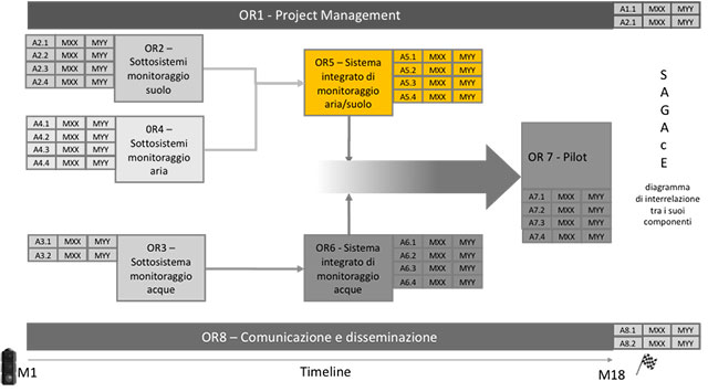
This WP concerns the implementation of the platform for input and visualization of data for air and ground monitoring, coming from the WP2 and WP4 sensors; the definition of the models of operational process for airborne missions; DSS implementation for data correlation and decision support; development of methods and algorithms for drone control
Act.5.1: The modeling of the aspects related to the aerial survey processes by drone with the technologies proposed by the project and the navigation of the off-line and on-line processes, during the missions, will be carried out. The detection processes and the interactions between the actors involved before- during- and post-monitoring will be modelled and made navigable for a rapid execution of the operations, in compliance with the regulations, operating re-engineering options where possible for improving performances.
Act.5.2: This activity includes: 1) Mission planning: development of methods and algorithms to optimize the scanning of the areas where the monitoring operations are carried out, taking into account the different sensors that can be embarked; 2) autonomous rescheduling of the trajectory: development of sensor-fusion methods to integrate measurements obtained from mission and navigation sensors; rescheduling the aircraft trajectory with minimum ground operator interventions based on real-time measurements; 3) Geolocation of the measurements.
Act.5.3: Implementation of a DSS for the correlation of the data acquired by the prototypes of WP2, WP4, to identify the types of pollutants and the risk levels of the monitored areas. Information will be provided (e.g. environmental toxicity, persistence) to understand the level of environmental risk (high/low/medium/zero) and support decisions for any monitoring and/or remediation operations, as well as for preventive screening activities in the areas more at risk, linking obtained data with geographical coordinates.
Act.5.4: Implementation of a prototype of software platform for input and visualization of data collected through the mission to allow: manual entry and association of the data acquired on the map if real time data is not available; reception and entry in real time during the mission; display of the route to follow/followed during the mission; comparison of data acquired at different times.